• 11 Posts
  • 111 Comments
Joined 1 year ago
cake
Cake day: June 15th, 2023

help-circle

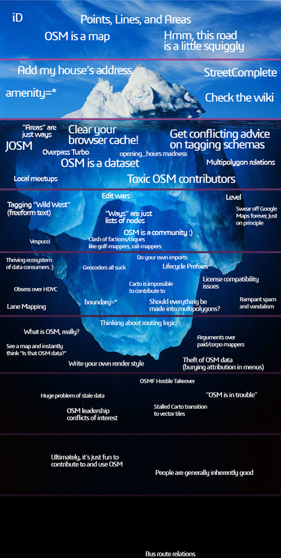
  • Overture maps is a project by osm supporting companies to present their fake and/or low quality data to their shareholders. They can’t import it to osm because of the aformentiones reasons, so they created their own osm with blackjack and hookers.

    Roads and landuse data is from osm so it it’s the same. Building contours based on osm and from some MS ai tool, similar to what you get in the RapId editor. At some places it’s good, in dense cities it’s unusable, and there are a lot of false positives, fake buildings on lakes and rivers, etc. Shops and POIs are from Facebook, a lot of them are at the wrong position or they not exist anymore, duplicates and jokes etc.

    So as I see, it’s not usable by itself for anything. But it’s license is compatible to osm, so you can freely copy from there. I used it to check validity of osm notes. Facebook via this allowed us to copy data from any page, it was a grey area before. Here where I live a lot of shops don’t have a website only a FB page, and it wasn’t clear if you can copy phone numbers, email addresses from there. Now the same data is available in overture


  • Some more details on the update frequency of services and maps I use:

    • After you upload something, it changes the database instantly.
    • Things getting data directly from there should also update near instantly, like when you download in JOSM.
    • The update delay of the raster map on openstreetmap.org depends on the zoom level. More zoomed in tiles update near instantly, lower zoom levels are updated weekly, monthly. Coastine is a special element, it doesn’t update with others, as it’s really resource intensive. https://wiki.openstreetmap.org/wiki/Coastline
    • Queries on Overpass-turbo.eu have a delay of 6-10 minutes.
    • Afaik StreetCompete quests are near instant, at the time you download them, but the base map updates only monthly, I read this in some forum, not sure.
    • Organic maps usually monthly. Map updates are tied to app updates, so sometimes they miss some month.
    • Magic Earth usually monthly, but sometimes they skip one or two. It’s annoying for me, because I use this for car navigation usually. The streets I use frequently are perfect now, but once I made a typo accidentally on a destination sign, and I fixed it some days later as I noticed while driving there, but ME didn’t updated its map for like 3 months after that, and I was always reminded to my typo I already fixed, ahhh…
    • Osmand defaults to monthly updates, but if you pay for it or download the foss version or you are a frequent osm contributor you can get live updates up to hourly frequency: https://osmand.net/docs/user/personal/maps-resources#osmand-live

    I wrote this from memory, so it may be not 100% up to date, please correct me if I’m wrong


  • infeeeee@lemm.eetoAndroid@lemmy.worldFond memories
    link
    fedilink
    English
    arrow-up
    6
    ·
    edit-2
    19 hours ago

    Early iOs and Android icons were one of the last offshoot of the style called “Frutiger Aero

    Flat icons don’t necessarily bad and undetailed, it’s just harder to create something more recogniseable with less tools, but I actually like the order, that they look like they are related to each other. Back in the day I created icon packs for the programs I used on pc, so my desktop would look clean and uniform.

    Design styles are in a cycle, just wait some years and they will show up again, I’m sure. There is already some connection with the new style of windows 11.


  • You don’t “submit changes to the osm team”, you are actually editing the live map. Reviewers can revert changes, but there isn’t some process a change must go through, everything is live. Most apps don’t use the live data, but regular snapshots of it, that’s why it seems like there is some processing behind the scenes, but it’s up to the renderers and apps, not by osm.

    Answering your question: OM is an app for navigation, and using the map, functionality for contributing data is very minimal and limited. SC is an app for contributing, nothing else, e.g. you can’t plan a route there. If you want to contribute, use SC. If you just navigating with OM and notice something is missing, use OM, if it’s quicker than opening another app.


  • One of them is a laptop, why ssh to the server isn’t an option? Set up tmux on the server so it always connects to the same session, so you can just continue where you left last time. If you need desktop support, rdp in gnome works really well.

    E.g if you connect with this command, and tmux is installed on the server, it will start a new session named “main”. If a session with that name exists it will connect to that:

    ssh -t pi@192.168.1.2 tmux new-session -A -s main

    Add something to .bashrc on the server to always do the same if you work on that phisically:

    if command -v tmux &> /dev/null && [ -n "$PS1" ] && [[ ! "$TERM" =~ screen ]] && [[ ! "$TERM" =~ tmux ]] && [ -z "$TMUX" ]; then
    tmux new-session
    fi


  • How would it otherwise? Network based location?

    Yes. Your phone could triangulate its location from nearby celltowers ane wifi networks. Google has a database of wifi routers (actually that was the point of google streetview, they collected wifi bssids alongside taking photos, they also collect this data from android devices).

    With microg you can select from different dbs for this, they are called ‘UnifiedNlp backends’: apple has a similar db from iphones, mozilla used to collect this data with a separate app for MLS (they shut down the project in 2024 march). Microg builds an on device private db as well, it will remembers the wifi networks and celltowers you were close to, and next time you are there it won’t need gps, saves a ton of battery life. This was called Deja Vu, I love this name. Search for UnifiedNlp on fdroid you can find some more options.

    Since MicroG 0.3 you don’t have to install these separately, Mozilla and Deja Vu are builtin, and they are more than enough


  • Huh? Which rom asks this? Usually you have to go through hoops to get microg, and only a handful of roms have it builtin. It can only ask if you want to enable microg not installing it or not, microg to correctly work it should be installed in /system/priv-app, to do that after boot on device, you have to be root.

    Do you use any app from aurora or outside fdroid? If your answer is no, than you can use android without a GMS package.

    Also as I wrote, location won’t work for you underground or inside concrete buildings. If you are fine with these kind of limitations than you can obviously.

    Marwin (the main developer of microg) said in some interview that he doesn’t want microg to exist, and in a perfect world we shouldn’t need such workaround. I would be also happy if android wouldn’t depend this muhc on google